• Skip to main content
  • Skip to primary sidebar
  • Skip to footer

Hiking around Flathead Lake

Welcome to Montana

  • Places to Hike
  • Places to Camp
  • Trailheads
  • Get Social

Things To Do

Flathead Lake Alpine Coaster

Montana’s First & Only Alpine Coaster is Now open!

Our attraction provides an entertaining family experience suitable for all ages. Our visitors can enjoy the thrill of speeding down the mountain at up to 27 miles per hour or opt for a more leisurely ride by using the brakes. Our location is conveniently situated near Glacier National Park, Whitefish, and Kalispell, Montana. We’re thrilled to welcome you to our coaster!

ADULT SINGLE RIDE:

$18.75 (over 56″ tall and 13 years old +)

​CHILD SINGLE RIDE:

$13.50 (36” tall and 3 – 12 years old. Must be with a driver 16 years old or older)

Filed Under: Things To Do, Tourism Tagged With: alpine coaster

Polson Bay Golf

Hours of operation at the Polson Bay Golf Course, 406-883-8230 are Monday through Sunday 7 am to 8pm.

While traveling through Polson there are a number of popular stops. If you are a golfer, the the ol’nine golf course is a taste of what once was. If you enjoy a more modern golf course, Polson also hosts an 18 hole course.

Polson Golf

The course has been open to the public since 1938. It has been a Mission and Flathead Valley favorite for years and years. There are 27 holes available for play. Every hole comes with spectacular views of both the mission mountains and Montana’s Flathead Lake.

While golfing the ol’ nine you will see the old clubhouse in the center of the course. The building was built during the WPA years, and now houses the Port Polson Players. The Players provide perfect programing with members and guest from the local communities. Be sure to consider a show in the air-conditioned theater.

The greens are green, the sky is blue and Montana’s Polson bay Golf course rises to the occasion, receiving a 4 Star Rating in Places to Play Golf by Golf Digest.

After your round of golf take some time to visit Bunkers Grill. Located on the Polson Bay Golf Course, 406-407-7656.

Filed Under: Things To Do Tagged With: golf, polson, port polson players

The Seli’š Ksanka Qlispe’ Dam, Formally KERR Dam

Went hiking around the Seli’š Ksanka Qlispe’ dam the other day. The gates are open wide at the south end of Flathead Lake. Really, if you haven’t seen it, it is worth the time spent. You wont even need bear spray. The staircase is steep on the way back up. Mike’s advise:  take it one step at a time.

See you on the trail.

The Seli’š Ksanka Qlispe’ Dam, Formally KERR Dam

The Dam is located on the Flathead Indian Reservation in northwest Montana. It is a concrete gravity-arch dam, built in 1938. The Dam is owned and managed by The Confederated Salish and Kootenai Tribes in conjunction with others. The purchase was complete in 2015. During the Confederated Salish and Kootenai Tribes’ celebration of their acquisition of the dam, the Tribal Council announced renaming the complex to reflect the three confederated tribes.

The Kerr Dam, officially known since 2015 as the Seli’š Ksanka Qlispe’ Dam

The Go Hike With Mike Trail Guide

Purchase the Go Hike With Mike Trail Guide. Read the Table of Contents

Thanks for stopping by.

Filed Under: Hiking, Things To Do, Tourism Tagged With: go hike with mike, trail guide

Go Hike With Mike Trail Guide

The Flathead Lake Trail Guide.

See you on the Trail.

If you have ben looing to hike around Flathead Lake you need to get to know Mike. The Go Hike With Mike Trail Guide post just about every trail.  Maybe you might stumble upon one not in the guide, but it is unlikely.

The guide is all about camping & hiking around Flathead Lake.

Go Hike With Mike Trail Guide

Mike has been hiking, wandering, hunting and spending time in these woods for more then 20 years.  The guide includes trails as far north as Polebridge, and the  Hungry Horse recreation area, and east to the Swan Front and Swan Valley.  To the north the guide contains trail head and campground information in and around Tally Lake.

Hiking Around Flathead Lake

The trail guide is focused on trails, camping and being in the woods.  Mike’s Flathead Lake Trail Guide breaks the area in five easy to use sections.  North of Flathead lake, including The Talley Lake area and due north to Polebridge. East of Flathead Lake, including the Swan Front, Swan Valley, and on into the Hungry Horse recreation area.   The guide contains most every trail Mike has hiked in the last 20 years or plans to hike in the next 20 years.

CLICK HERE TO PURCHASE YOUR COPY.

Don’t need the hiking guide, just some basic trail information, do not fret.  Mike has included some beginner to medium hikes on this website.  Depending on were you as staying there is most likely a trail head near you. Thanks for visiting, hope to see you on the trail.

Follow Mike on Instagram or subscribe to his YouTube Channel

#gohikewithmike

Filed Under: Hiking, Things To Do, Tourism Tagged With: go hike with mike, hiking, trails

Hiking around Flathead Lake

Hiking around Flathead LakeThere are many quality hiking very close to Montana’s Flathead Lake.  The views from these hikes around Flathead Lake are both beautiful and vast.  Hiking is a great way to explore the area while experiencing nature and wildlife. We have created a list of trails you may enjoy.  The list of trails when hiking Flathead Lake can be found below.

Each trail offers an adventure into the vast openness of untouched country and environment.

First things first, when hiking around Flathead lake you should be sure to carry bear spray.  Be sure to carry it with your finger in the hole, and your thumb on the safety.  Really, be safe, carry bear spray.  With that said there are ample hiking opportunities around Flathead Lake.

Get your  150+ page Flathead Lake trail guide. or visit the website: GoHikeWithMike.com

Hiking Trail: Crane Mountain Trail #314

Of the three trails on this page, this trail is best if you are looking for aerial views of Flathead Lake. The Crane Mountain trail is 2.1 miles long (total of 3.5 miles from trailhead) and climbs about 330 feet. It begins at the junction with the Beardance Trail #76 and ends at the junction with Road #10218 near Crane Mtn Rd. From the Beardance trailhead this is one of three trails that climb up Crane Mountain. This lesser known trail starts winding up a few switchbacks through a larch/pine forest with thick undergrowth. It then straightens out and parallels Crane Creek to an old road bed. Turning left, follow the level road out to the upper trailhead. The trail is open for the following uses: hiking, horseback riding, and mountain biking.

From Bigfork, go south on Highway 35 past Woods Bay and turn right after mile marker 23, entering the Beardance trail head parking. The trailhead is on the east side of the highway.

Hiking Trail: Noisy Creek Trail #8

The Noisy Creek trail is 1.9 miles long and climbs 850 feet. It begins at the end of Jewel Basin Road #5392 and ends at the junction with Alpine Trail #7. This is one of many accesses to the Jewel Basin Hiking Area. The trail is open primarily for the following uses: Hiking. Other uses are allowed, but not recommended, up to the Hiking Area boundary.

From Bigfork, go north on Highway 35 for 2.3 miles and turn right onto Hwy 83. Stay on Hwy. 83 for 2.8 miles and turn left onto Echo Lake Road. After 2.2 miles, turn slightly right onto the Foothills Road. After 1.1 miles, turn right onto Rd. # 5392, following the Jewel Basin Road signs. The trailhead is 6.6 miles at the end of the road. Trail #8 starts at parking lot see information boards to make sure you are starting on the right trail as there are several that leave the parking lot.

It doesn’t matter if you are a novice hiker or you love a challenge: Jewel Basin has a hike for you. You’ll discover 15,349 acres of wilderness, 27 lakes and nearly 50 miles of hike-only trails.

The Jewel Basin is located just outside of Bigfork in the Flathead National Forest. To access the trailhead from Bigfork, take Hwy 35 north to Hwy 83.  Head east on Hwy 83 to the junction of the Echo Lake Road. Head north on Echo Lake Road about 3 miles to junction with the Jewel Basin Road (No. 5392).  Follow this road approx. 7 miles to the trailhead.

Hiking Trail: Crater Notch Trail #187

The Crater Notch Trail is 3.7 miles long and climbs about 3,000 feet. It begins 1/2 mile up the Echo-Brokenleg Trail #544 and ends at the Alpine Trail #7 leading to In-thlam-keh Lake. The trail is open for the following uses for the first 2.7 miles: hiking, horseback riding, and mountain biking. After 3.5 miles the trail enters the Jewel Basin Hiking Area where the only allowed use is hiking. Please respect these guidelines.

From Bigfork, go north on Highway 35 for 2.3 miles and turn right onto Hwy. 83. Stay on 83 for 2.8 miles, turning left onto Echo Lake Rd. After 2.2 miles, merge slightly right onto the Foothills Road. After 1.1 miles turn right onto Road #5392 also called Jewel Basin Rd. The trailhead is about two miles up the road on the right.

FLATHEAD LAKE TRAIL GUIDE

Hiking in MontanaThe Go Hike with Mike trail guide contains most every trail head in the Flathead and Kootenai Forest as well as the Mission Mountain Tribal Wilderness.  Click here to purchase your copy.

Follow Mike on Instagram or subscribe to his YouTube Channel

#gohikewithmike

Filed Under: Hiking, Things To Do Tagged With: flathead lake, hiking, montana

Montana’s Flathead Lake

Montana’s Flathead Lake is the largest natural freshwater lake in the western United States. Lying in the Flathead Valley of Northwest Montana, the Lake is more then 300 feet deep and extends north and south some 28 miles and is seven to 15 miles wide.

As you drive and drive on the roads that hug Flathead Lake’s shoreline, (US Highway 93 on the west and Montana Route 35 on the east) it’s hard to believe manmade dams that are so common in the Pacific Northwest didn’t create it. Rather, the lake is a fortuitous product of the activity of ice-age glaciers, and is fed by the Swan and Flathead Rivers.

Montanas Flathead Lake

Montana’s Flathead Lake

All manner of water sports are enjoyed upon its 200 square miles of surface. Several state parks and lakeshore communities have boat launches and marinas on the Lake.

Locals know summer has arrived when a steady stream of traffic starts to build on the secondary roads. So in peak season expect to share your enjoyment of the Flathead Valley with many others, although the mountains still offer room to get-away if you are willing to exert yourself.

You can avail yourself of a boat tour or rent one of the many types of watercraft including canoes, kayaks, windsurfers, hydro bikes, sailing and fishing boats. Serious anglers can arm themselves with heavy-duty equipment and probe the 300-foot deep Flathead Lake for trophy Mackinaw. Lake trout, salmon, perch, pike, bass, and whitefish are found in the Flathead area’s many lakes.

There are many hiking trails around the area as well.

If you are looking for the area’s premiere trail guide take a look at Go Hike With Mike trail guide.

This GHWM website contains information about camping & hiking around Flathead Lake.   Mike has been hiking, wandering, hunting and spending time in these woods for more then 20 years and this guide contains most every trail head around Flathead Lake.

#MontanasFlatheadLake

Montana's Flathead Lake

There are  185 miles of shoreline and 200 square miles of natural  freshwater.  Therefore earning the title as “the largest natural freshwater lake west of the Mississippi”.  There are 13 public access sites around The Lake maintained by  Montana Fish Wildlife and Parks

The southern half of The Lake lies within the boundary of the Confederated Salish and Kootenai Tribes’ Flathead Reservation, which was created in 1855 by the Hellgate Treaty. The Flathead Nation insists that all non-tribal members purchase a tribal recreation permit to recreate on tribal lands.

Public access sites include: Bigfork, Elmo, Juniper Beach, and Sportsman’s Bridge.
There are a number of Public State Parks including: Big Arm, Finley Point, Wayfarers, West Shore State Park, Woods Bay, and Yellow Bay, and Wild Horse Island.

Filed Under: Things To Do Tagged With: flathead lake

Mission Mountains Wilderness

Mission Mountains Wilderness
Located in the Flathead National Forest in Montana. 

The Mission Mountains Wilderness is on the Swan Lake Ranger District of the Flathead National Forest in northwestern Montana. The Forest Service manages it as part of the National Forest System. Officially classified as Wilderness on January 4, 1975, the 73,877 acre area is managed in accordance with the Wilderness Act of 1964.  The Mission Mountains run along the east shore of Montana’s Flathead Lake.

The Mission Mountains, Holland LakeWhen to Visit – Most people visit the wilderness between July 1 and October 1. Snow-filled passes and high streams make earlier travel difficult and hazardous. High lakes do not open up until early or mid-June.

June is normally a wet month. Snow still covers high, shaded basins and surrounds trees.

July, August, and early September are dry months. Daytime temperatures are the 80-90 degree range. Showers are frequent. Nights are very cool. Snow occur at any time. Heavy snow generally occurs in late October and early November.

Mission Mountains Trail HeadIf you are a skier or winter camper, late February through May provide the best snow conditions and longer days. When planning an extended backcountry trip, be informed of potential avalanche conditions.

Trails – There are about 45 miles of maintained Forest Service system trails in the Mission Mountains. Most trails are better suited to hiking than horseback riding because of rugged terrain.

Travel is primarily by foot with some horseback use. Mountain bikes, hang gliders, motorized trail bikes, motorcycles, three and four wheelers, and snowmobiles are not permitted. Few of the trails can be called easy. Some are especially difficult because of steepness. You should be an experienced hiker to travel cross country and should possess map reading and compass skills.

Throughout the Mission Mountains you will find old Indian and packer trails. These are usually steep and difficult to follow. They are suitable for only the most experienced horse users or backpackers.

Mission Mountain TrailAccess Points – The major access points into the Mission Mountains Wilderness from the Swan Valley: Glacier Creek, Cold Lakes, Piper Creek, Fatty Creek, and Beaver Creek. Other access points from the Swan Valley include Lindbergh Lake (south end trail reached by boat), Jim Lakes, Hemlock Creek, Meadow Lake, and Elk Point.

There are also three major access points from the Salish & Kootenai Indian Reservation side of the Mission Mountains. Access through tribal lands requires a permit. These permits may be purchased at major sporting goods stores in Missoula and the Mission Valley or through the Confederated Salish and Kootenai Tribal Recreation Department in Pablo, Montana, phone (406) 675-2700.

A major portion of the Mission Mountains is suitable for backpacking only. Travel is strenuous, but it has many advantages: independence and self-sufficiency, opportunities for solitude, and you’re more carefree when backpacking.

DAY HIKES: The Mission Mountains has several hikes ranging from 1 1/4 miles to 6 miles (one way) which can be completed in a day. You will carry less on your back and travel more easily.

BACKPACKING: Backpacking requires careful planning. Proper equipment, with maximum utility and minimum weight, will make the trip easier. The most important items will be your pack, sleeping bag, and foot gear. Take only what you need. A pack that is too heavy can spoil your trip. A pack without adequate food, clothing and shelter can be equally disappointing and unpleasant.

The Go Hike With Mike trail guide contains most every trailhead along the Swan front of the Mission Mountains.

Looking west at Flathead Lake from Yellowbay State Park.

Follow Mike on Instagram or subscribe to his YouTube Channel

#gohikewithmike

Filed Under: Hiking, Things To Do, Tourism Tagged With: camping, hiking, mission mountains

Pablo Wildlife Refuge

Mirror on Pablo ReservoirPablo Wildlife Refuge is located on tribal trust lands of the Confederated Salish and Kootenai Tribes. It is superimposed on the irrigation reservoir managed by the Bureau of Indian Affairs Flathead Irrigation Project.

Pablo Wildlife Refuge is 2,500 acres of water, marsh, and upland grassland. The refuge provides nesting and resting areas for migratory birds and other wildlife.

Shaped by glacial activity approximately 12,000 years ago, the terrain surrounding Pablo NWR is rolling and interspersed with many pothole wetlands.

Visitor Opportunities 

Fishing is permitted on Pablo NWR in accordance with applicable State, Federal, and Tribal regulations. Yellow perch and largemouth bass are caught at Pablo NWR. Ice fishing is permitted after the waterfowl hunting season has ended and the refuge reopens.

Pablo Wildlife Refuge
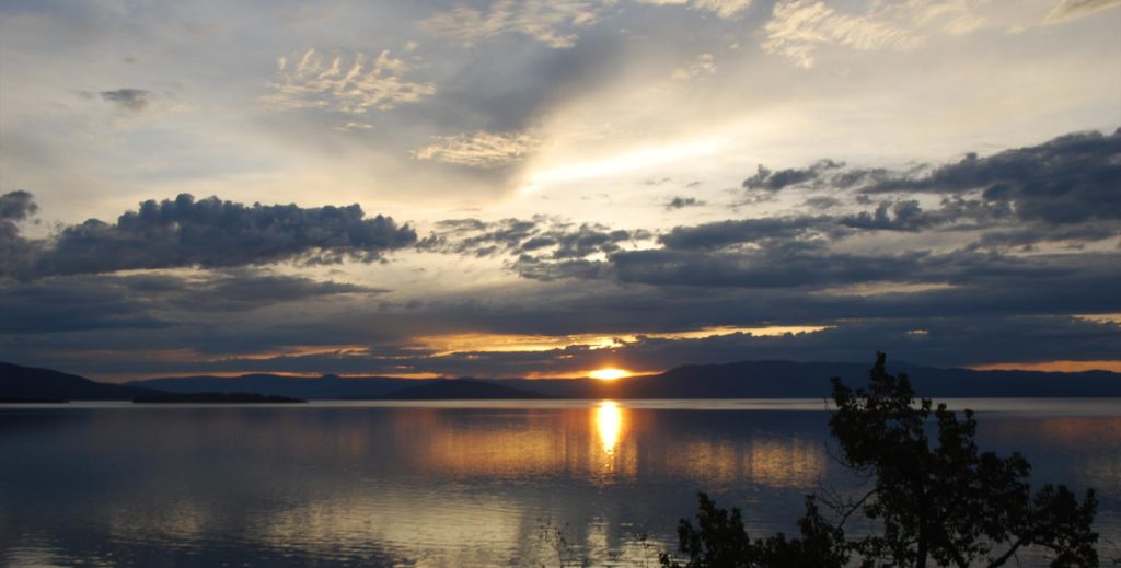
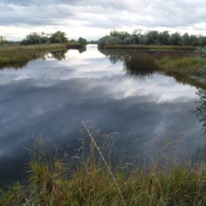
Photography and wildlife observation are encouraged. Waterfowl numbers vary throughout the year. There may be as many as 80,000 in October and November, and half that number in late March and through early May. A few ducks and geese may spend the winter. Nesting begins in late March and lasts through July. The most numerous nesting species are Canada geese, mallards, and redheads. Pintail, American widgeon, shoveler, blue and green-winged teal, ruddy duck, gadwall, common merganser, and coot are also present. Other species of water, marsh, and upland birds are abundant from May to October. Common loons are occasionally seen and this is a good area to see Bald Eagles.

Common mammals on these refuges are the field mouse or meadow vole, muskrat, and striped skunk. Mink, badgers, and porcupines have also been observed.

Management Programs 

Although water levels are controlled primarily for irrigation and flood control, the Fish and Wildlife Service works closely with the Flathead Irrigation Project to insure that water levels are properly maintained to accommodate nesting waterfowl. A portion of the refuge is closed each spring to minimize disturbance in nesting areas, and the refuge is closed entirely during the hunting season. There is an active Bald Eagle nest on the Refuge which regularly fledge one to two young per year. In 1996, a release of 19 trumpeter swans was conducted by the Confederated Salish and Kootenai Tribes, Montana Department of Fish Wildlife and Parks and the USFWS with the hope of re-establishing a breeding flock in the valley.

Efforts to improve wildlife habitat over the years have included planting food and cover crops for upland game birds, the construction of nesting islands for waterfowl, and prescribed burning to enhance brooding areas and provide browse for Canada geese. Biological, chemical and mechanical methods are used to control some species of non-native plants which have begun encroaching on the refuge. Aerial surveys are conducted periodically to monitor waterfowl numbers and nesting success.

The refuge is closed to hunting. Adjoining State-owned lands are managed by the Montana Department of Fish, Wildlife and Parks for wildlife cover, food production, and public hunting. These lands are open to hunting on a first-come-first served basis for waterfowl and pheasant shooting. The closure of Pablo NWR enhances the quality of hunting in the Flathead Valley.

Directions 

Pablo National Wildlife Refuge is located approximately 75 miles north of Missoula and 3 miles south of Polson. Turn west on Reservoir Road 3 miles south of Polson. Traveling west for 1-1/2 miles will bring you to the kiosk for Pablo NWR. The dike road is open for travel during daylight hours through the summer. There are several county roads bordering the Refuge.

#MontanasFlatheadLake

Filed Under: Hiking, Recreation, Things To Do Tagged With: pablo, refuge

  • Page 1
  • Page 2
  • Go to Next Page »

Primary Sidebar

Purchase Your Copy

GoHikeWithMike Trail Guide Download.

Go Hike With Mike Trailguide in Paperback from Amazon

Hiking Around Flathead Lake

  • Awards
  • Bears
  • Bigfork
  • Boat Rentals
  • Cabinet Mountains
  • Campgrounds
  • Canvas Art
  • Clacier National Park
  • Fishing
  • Flathead
  • Flathead Lake
  • Flathead River
  • Gear
  • Glacier Park
  • Hiking
  • Hiking Trails
  • History
  • Holland Lake
  • Home Decor
  • Hungry Horse
  • Jewel Basin
  • Mission Mountain Wilderness
  • Mission Mountains
  • Mountain Top Views
  • National Parks
  • Paperback
  • Permits
  • Places to Camp
  • Places to Hike
  • Recreation
  • Reviews
  • Shopping
  • Swan Front Trails
  • Tent Camping
  • The Bison Range
  • Things To Do
  • Tourism
  • Trail Heads
  • Trails
  • Vacation
  • Videos
  • Videos
  • Wildlife
  • Yellow Bay

Trailheads

Go Hike With Mike

Permits

Recreation Permits

Equipment

Hiking Equipment

Looking for the Vacation Guide?

Montana's Flathead Lake Vacation Guide

Purchase the Flathead Lake Vacation Guide

on You Tube

Subscribe to Mike’s YouTube Channel.

Now in Paperback from Amazon


The Go Hike With Mike Trailguide
The Go Hike With Mike Trail Guide in Paperback

Footer

On The Trail:

Go Hike With Mike Website: GoHike WithMike.com

Go Hike With Mike Email: trails@gohikewithmike.com

Go Hike With Mike Social: #GoHikeWithMike

Hiking on Flathead Lake

alpine coaster Bigfork camping canvas art family fun finley point fishing flathead lake glacier Glacier National Park Glacier Park go hike with mike golf Guide hiking history Home Decor Hungry Horse indian indians mission mountains montana national pablo park permits polson port polson players refuge reservation sunrise Swan Front tourism tourist trailguide trail guide trail heads trails Vacation vacation guide vacation hjikes video videos wildlife yellow bay

Another Hiking Video from Go Hike With Mike

https://youtu.be/CyHdRucBpvE

Flathead Lake Trail Guide

The Go Hike with Mike trail guide contains most every trail head in the Flathead and Kootenai Forest as well as the Mission Mountain Tribal Wilderness.  Click here to purchase your copy.

Follow Mike on Instagram or subscribe to his YouTube Channel

#gohikewithmike

  • Camping Around Flathead Lake
  • Flathead Lake Trails and Camping
  • The Go Hike With Mike Trail Guide

Go Hike with Mike

Go Hike With Mike Website: GoHike WithMike.com
Go Hike With Mike Email: trails@gohikewithmike.com
Go Hike With Mike Social: #GoHikeWithMike
Go Hike With Mike GoHikeWithMike Trailguide Download.

Go Hike With Mike Go Hike With Mike Trailguide in Paperback from Amazon